Archaeologists working at the ancient Maya site of Chactún in Mexico say they’ve uncovered what may be a 3,000-year-old map of the cosmos. The layout of the stone structures with long causeways radiating outward appears to mirror the Maya understanding of the universe, linking earthly space with celestial order.
If confirmed, it would be one of the earliest known examples of Maya astronomical planning, offering new insight into how early communities mapped both their world and the heavens.
Archaeologists Say They’ve Found a 3,000-Year-Old Map of the Cosmos at an Ancient Maya Site in Mexico
https://www.smithsonianmag.com/smart-news/archaeologists-say-theyve-found-a-3000-year-old-map-of-the-cosmos-at-an-ancient-maya-site-in-mexico-180987656
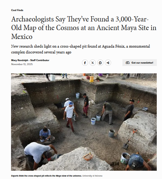
"Inside the pit, researchers found colored pigments that correspond with the four cardinal directions. For instance, blue is used to mark north, while yellow is associated with south.
Additionally, the east-west axis of the structure aligns with the sunrise on October 17 and February 24—“a 130-day span that probably represents half of the 260-day cycle of the Mesoamerican ritual calendar,” according to a statement from the university.
The monumental structure was built many years before the development of ancient Maya hierarchies. As such, researchers think Aguada Fénix wasn’t constructed using forced labor. If more than 1,000 workers came together to complete the project, the structure could have been finished “within several years,” according to the researchers.
“We have this perception that to do a big thing, you have to have hierarchical organization, and that’s the way it happened in the past,” Inomata explains to CNN’s Katie Hunt. “But now we are getting an image of the past which is different.”
Report Ad
Inside the cross-shaped pit, researchers also found jade sculptures of a crocodile, a bird and potentially a woman during childbirth. They say these items reflect everyday experiences, providing additional evidence for the lack of hierarchy.
“Usually, if you have kings or rulers, they are represented in sculptures or paintings, or they live in big palaces,” Inomata tells Benjamin Taub of IFL Science. “We don't have any of those at Aguada Fénix.”
In the early stages of the research, the archaeologists used lidar, a technique that involves emitting pulsed lasers from an airplane and measuring how long it takes them to return. Using this data, experts can create a map of the landscape’s surface.
Quick fact: How archaeologists use lidar
In a study published this year, a researcher used lidar scans to reveal traces of a 600-year-old city in southern Mexico.
Technologies like lidar are helping archaeologists uncover traces of history that are hiding in plain sight.
Report Ad
“I think it’s very cool that new technologies are helping to discover these new types of architectural arrangements,” co-author Xanti S. Ceballos Pesina, an anthropologist at the University of Arizona, says in the statement. “And when you see it on the map, it’s very impressive that … people with no centralized organization or power were coming together to perform rituals and to build this massive construction.”
#Archaeoastronomy #Cosmology #Indigenous #NDNZ